Show Posts

This section allows you to view all posts made by this member. Note that you can only see posts made in areas you currently have access to.


Topics - Maxxi

Pages: 1 [2] 3 4 5 6 7 ... 9
16
Hello! Today I'll be teaching you how to edit your cache.db to point to your own custom brick textures that will show up on servers and your own!
GUIDES: http://forum.blockland.us/index.php?topic=280349.0
Before doing this, make sure your game is closed and you don't have this running, otherwise this might not work for you.
I am not responsible for anything you can possibly damage editing your cache.db. Proceed the following steps with caution.
Also, this seems to work for the steam version only as of now, unless you have the brick textures selected as read-only, this tutorial is for steam only for right now.

Hello! I'm making a tutorial after finding out a neat way for some of the people who don't use shaders out there to fix Brick Textures!
For this tutorial, I'm going to be using Manty's Brick Textures, which you can download here.
You're going to need a program called Sqlite Expert. It's a free version so theres no need to worry about paying for it, head over to the download section and grab the personal version.
We also need to grab the SHA1 of Blockland's Brick Textures, I'll make it easy for you and leave the SHA1's here, they're the same for every cache.db.

Quote
ffb06aeea8388d4e166bca1d6a5ca dbdc74ca5f2 - brickTOP
92122e47fac26fea3a0b4d32e19a4 4fa425984b0 - brickSIDE
95047ef708a1b6b62e4eba6cb7945 d1517e98a8b - brickRAMP
6174a39abf253faa44de7050c331b 4bbdb80f27e - brickBOTTOMLOOP
8bc1ec1b29173dae4a9a45783fd8f 6dc6d7ffb13 - brickBOTTOMEDGE

The SHA1 of each texture is different, so for example brickTOP is a series of numbers and letters, and brickSIDE is different.
Alright, you're going to want to put your brick textures in your base/data/shapes folder, which can be found at "C:\Program Files (x86)\Steam\steamapps\common\Blockland\base\data\shapes" for steam users. Simply drop them in there and it'll ask to replace the files,  click Yes.
Now open Sqlite Expert and Click "File" and go to "Open Database". A window titled "Select database file" will pop up, simply navigate to your Blockland folder and click on the cache.db.
You should now see something like this:


Click on blobs, and you'll get another window like this:


Now click on "Click here to define a filter" and press Enter. You should now be able to search for certain SHA1's.

Alright, here's the tricky part. Remember those SHA1's I gave you earlier? Copy brickTOP's SHA1, which is "ffb06aeea8388d4e166bca1d6a5ca dbdc74ca5f2". And paste it into the filter, and hit enter. You should now see something like this:

Double click on the little texture under the "data" tab, which you will then get a window to pop up and you will see several buttons, click on "Image Editor".
You should now see this:

Click on "Load", you'll get another window that says "Open".
Navigate to your "C:\Program Files (x86)\Steam\steamapps\common\Blockland\base\data\shapes" directory and double click on the brickTOP texture.
You should now have the window change to this:


Your SHA1 should now be focusing on using the custom texture, in this case when I used Manty's, it changed to this:


Click OK and OK again on the Record Editor window and do the same for every other texture, it's best to go top to bottom on the list so it helps more when finding the right texture.

Do the same steps listed above with every other SHA1, follow down the list and proceed onto "brickSIDE" and whatnot. Be careful.

When following through this tutorial, make sure to not mess anything up with your cache.db.
If this is done right this will work. It has worked for me many times and with many different custom textures.
Anything you do that messes up your cache.db I am not being withheld responsible for. Do this at your own risk.

17
Off Topic / Post ur graids v233234 (before and after edition)
« on: May 07, 2015, 11:45:37 PM »
Post your grades from now and compare from 6 months ago
Now: all b's
technology is an A because im really good with compootors and my industrial tech teacher says that i could possibly be running a junior college class since my knowledge for it is at that level after showing some of the stuff i can do (he worked in a college for technology and now works at our middle school)

6 months ago: C in math, D's in every other class

18
i found this on battlemix, its this yellow sniper rifle thats long as forget and its just gibberish letters and it shoots rockets and stuff
i cant find it help

19
Off Topic / Where is the actual first post?
« on: May 03, 2015, 01:31:55 PM »
Now that the forum is probably coming close to being 10 years old, where is the actual first post?
Does anyone wonder this?
There has to be a first post on this forum somewhere.
It just sounds interesting.
discuss

20
Forum Games / [1280x720] Time - gun to my HEAD forget
« on: April 16, 2015, 08:54:40 PM »
You're uh, dreaming.


You stop dreaming.
You wake up and find yourself in a room.

Terminal with a box on it, great start.
You ran away, and didn't know what to do. You hit a switch on a machine you have and you're here now.
You are at a terminal, dating 1983, this looks like nothing you have seen before. You have your phone, which has a strange prompt on it, asking you to "SET TIME"?
The date is January 9th, 1983, and you don't like it. You want to get out of it. What date do you go to?

Note: I currently can't find my stuff that I use to draw with, I'll find it eventually.

21
Off Topic / PSA for everyone currently in Illinois
« on: April 09, 2015, 04:28:00 PM »
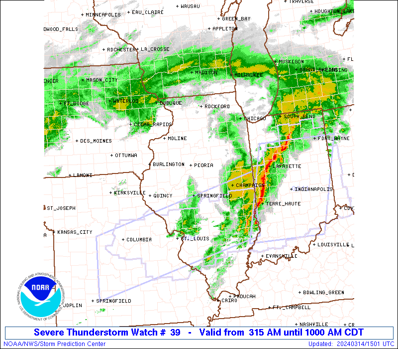
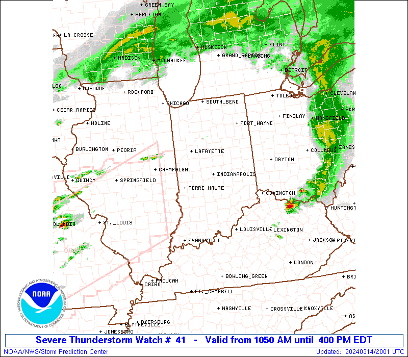
As of right now there are two tornado watches in effect for all of northen to extreme central illinois and there have been several lines of storms.
Current tornado risk as of 3PM

Current outlook for April 9th, 2015
Quote
   ...THERE IS AN ENH RISK OF SVR TSTMS FROM THE ARKLATEX NORTHEAST
   INTO THE SRN GREAT LAKES/LOWER OH VALLEY...

   ...THERE IS A SLGT RISK OF SVR TSTMS SURROUNDING THE ENH AREA FROM E
   TX INTO THE UPPER OH VALLEY...WV AND WRN PA...

   ...THERE IS A MRGL RISK OF SVR TSTMS SURROUNDING THE ABOVE AREAS
   FROM S CENTRAL TX TO THE CENTRAL APPALACHIANS...

   ...SUMMARY...
   SEVERE THUNDERSTORMS ARE LIKELY TODAY INTO TONIGHT OVER A BROAD
   SWATH FROM PARTS OF TEXAS NORTHEASTWARD THROUGH THE LOWER AND
   MID-MISSISSIPPI VALLEYS INTO THE OHIO VALLEY AND SOUTHERN GREAT
   LAKES. THESE WILL PRODUCE DAMAGING WIND...HAIL...AND A FEW
   TORNADOES...ONE OR TWO OF WHICH COULD BE STRONG.

   ...MID-MS VLY TO SRN GRT LKS...AND LWR OH VLY TO E TX/LWR MS VLY...
   NO CHANGES ARE NEEDED WITH THIS OUTLOOK ISSUANCE FOR THE SLIGHT AND
   ENH AREAS...AS PREVIOUS FORECAST DISCUSSION REMAINS ON TRACK FOR
   THIS AFTERNOON INTO TONIGHT.  THE GENERAL TSTM AREA AND MARGINAL
   SEVERE RISK AREA HAVE BEEN TRIMMED EWD SOME ACROSS WRN MO AND
   NERN-SRN OK...GIVEN THE ADVANCEMENT OF THE COLD FRONT.

   ...UPR OH VLY/CNTRL APPALACHIANS...
   THE ERN PART OF THE SLIGHT RISK AREA HAS BEEN EXPANDED EWD TO
   INCLUDE MORE OF WV AND INTO WRN PA...WHERE HAIL AND DAMAGING WIND
   THREATS ARE EXPECTED THIS AFTERNOON AND EVENING.  OBJECTIVE brown townYSES
   INDICATED MUCH OF THE ENVIRONMENT ACROSS SRN OH INTO WV AND PARTS OF
   WRN PA HAS CONTINUED TO DESTABILIZE THIS AFTERNOON.  THIS COMBINED
   WITH AN INCREASE IN EFFECTIVE BULK SHEAR WILL CONTINUE TO SUPPORT A
   THREAT FOR STRONG TO SEVERE STORMS.

   ...SC...
   GIVEN RECENT CONVECTIVE/TSTM DEVELOPMENT ALONG THE SEA BREEZE...THE
   GENERAL TSTM AREA HAS BEEN EXPANDED EWD SOME TO ACCOUNT FOR ANY
   ADDITIONAL TSTMS.

   ..PETERS.. 04/09/2015

   .PREV DISCUSSION... /ISSUED 1130 AM CDT THU APR 09 2015/

   ...SYNOPTIC SETUP...
   PROGRESSIVE...MULTI-STREAM FLOW WILL PREVAIL OVER THE CNTRL AND ERN
   U.S. THIS PERIOD...DOWNSTREAM FROM WRN STATES SPLIT. STRONG
   SHORTWAVE TROUGH NOW EXITING THE CNTRL HIGH PLNS SHOULD ACCELERATE
   ENE INTO ERN IA THIS EVE...BEFORE FURTHER ACCELERATING AND TURNING
   NE TO NEAR SSM EARLY FRI AS NRN BRANCH IMPULSE AMPLIFIES SE INTO MN.
   AT THE SAME TIME...WEAKER LEAD DISTURBANCE NOW CROSSING THE OZARKS
   SHOULD MOVE NE INTO THE MID-OH VLY BY THIS EVE...AND INTO NY/PA
   EARLY FRI...AS DEEP SWLY FLOW STRENGTHENS ACROSS THE E-CNTRL AND ERN
   U.S.

   AT THE SFC...NW MO LOW EXPECTED TO DEEPEN NEWD INTO SRN WI BY THIS
   EVE...AND UNDERGO FURTHER DEEPENING AS IT REACHES THE SSM AREA EARLY
   FRI. COLD FRONT TRAILING SSW FROM THE LOW SHOULD STRENGTHEN AND
   ACCELERATE E ACROSS THE MID-MISSISSIPPI VALLEY AND OZARKS BY LATE
   TODAY...AND INTO THE UPR OH...TN...AND LWR MS VLYS EARLY FRI...WHILE
   MORE DIFFUSE WARM FRONT ADVANCES N INTO LWR MI.

   IN SUMMARY...THE OVERALL SET-UP SUPPORTS A BROAD AREA WITH AN
   APPRECIABLE RISK FOR SVR WEATHER LATER TODAY THROUGH EARLY FRI...BUT
   WITH MITIGATING FACTORS THAT LIKELY WILL KEEP THE CORRIDORS OF
   GREATEST RISK SOMEWHAT FRAGMENTED AND MULTI-MODAL.

   ...MID-MS VLY TO SRN GRT LKS THIS AFTN THROUGH EARLY TNGT...
   SEVERAL FACTORS MAY COMBINE TO YIELD A MESOSCALE CORRIDOR OF
   SOMEWHAT ENHANCED SVR THREAT...INCLUDING THE POTENTIAL FOR A COUPLE
   STRONG TORNADOES...OVER THE ERN IA/NE MO/NRN IL/SRN WI AREA LATER
   TODAY INTO EARLY TNGT. PERSISTENT HEIGHT FALLS ACROSS
   REGION...LARGELY DUE TO AMPLIFICATION OF UPSTREAM...LARGER-SCALE
   TROUGH...WILL OFFSET SINKING/DESCENT OCCURRING IN WAKE OF LEAD UPR
   IMPULSE AND EMBEDDED MCV NOW CROSSING THE OZARKS. AT THE SAME
   TIME...SATELLITE SUGGESTS LIKELIHOOD FOR AT LEAST MODEST SFC HEATING
   AHEAD OF COLD FRONT AND DEEPENING SFC LOW APPROACHING FROM NW MO.

   WITH 700 MB SWLY WINDS INCREASING TO AOA 60 KTS ATOP 40+ KT SSW FLOW
   AT 850 MB...HODOGRAPHS WILL BE FAVORABLE FOR SUSTAINED SUPERCELLS
   WITH LARGE HAIL. THE DIRECTIONAL COMPONENT TO LOW-LVL SHEAR LIKELY
   WILL NOT BE GREAT. BUT COMBINATION OF STRENGTHENING FLOW AND
   EXPECTED BACKING OF NEAR-SFC WINDS/ENHANCED SRH IMMEDIATELY AHEAD OF
   SFC LOW SUGGEST THAT A CORRIDOR OF HEIGHTENED TORNADO POTENTIAL
   COULD EVOLVE LATER THIS AFTN...BEFORE THE STORMS MERGE INTO BROKEN
   LINES/SMALL CLUSTERS EARLY TNGT. ALTHOUGH CLOUDS AND SHOWERS MAY
   DELAY NWD ADVANCE OF WARM FRONT ACROSS IL/IND...STRENGTHENING SFC
   PRESSURE FALLS/TRACK OF SFC LOW FURTHER INDICATE THAT THE SVR THREAT
   COULD EXTEND NWD INTO SRN WI AND SW LWR MI...WITH DMGG WINDS
   BECOMING THE DOMINANT THREAT OVER TIME.

   ...LWR OH VLY SW INTO E TX/LWR MS VLY LATE TODAY THROUGH EARLY
   FRI...

   SFC HEATING AND UPLIFT ALONG COLD FRONT AND PRE-FRONTAL CONFLUENCE
   AXES EXPECTED TO INITIATE TSTMS LATER TODAY THROUGH TNGT AS EML CAP
   IS BROKEN. ALTHOUGH WIND FIELDS WILL BE WEAKER RELATIVE TO POINTS
   N...AMPLE /40+ KT/ WSWLY DEEP SHEAR WILL EXIST FOR SUSTAINED
   STORMS/SUPERCELLS...ESPECIALLY OVER THE LWR OH AND TN VLYS. GIVEN
   FAIRLY RICH MOISTURE AVAILABILITY /PW AOA 1.50 INCHES/...IN THEIR
   EARLY STAGES THESE STORMS COULD YIELD LARGE HAIL AND A FEW
   TORNADOES. WITH TIME...DEGREE OF LOW-LVL FORCING SHOULD RESULT INTO
   AMALGAMATION OF CONVECTION INTO AN EXTENSIVE...BROKEN SQLN. EMBEDDED
   LEWPS AND BOWING STRUCTURES LIKELY WILL BE ACCOMPANIED BY A SLOWLY
   DIMINISHING RISK FOR DMGG WIND INTO EARLY FRI.

   ...UPR OH LY/CNTRL APPALACHIANS THIS AFTN/EVE...
   A CONDITIONAL RISK WILL EXIST FOR LOOSELY-ORGANIZED CLUSTERS OF
   MAINLY MULTICELL STORMS WITH HAIL AND LOCALLY DMGG WIND THIS AFTN
   OVER PARTS OF OH...KY AND WRN SLOPES OF THE CNTRL
   APPALACHIANS...WHERE SFC HEATING WILL FURTHER DESTABILIZE REGION OF
   MODEST LOW-LVL MOISTURE AND MID-LVL INSTABILITY. SOME OF THIS
   ACTIVITY COULD ARISE FROM EXISTING AREAS OF ELEVATED CONVECTION NOW
   OVER PARTS OF THE REGION...WITH OTHER STORMS INITIATED BY
   DIFFERENTIAL HEATING ALONG RESIDUAL SFC BOUNDARIES. MOST OF THE
   STORMS SHOULD WEAKEN WITH NIGHTFALL...ALTHOUGH PARTS OF THE OH VLY
   COULD EXPERIENCE A SECOND ROUND OF STORMS LATE TNGT AS MID MS VLY
   COLD FRONT APPROACHES REGION.
Current Tornado Watches
http://www.spc.noaa.gov/products/watch/

Tornado Watch #39 (west illinois into eastern iowa)

Quote
URGENT - IMMEDIATE BROADCAST REQUESTED
   TORNADO WATCH NUMBER 39
   NWS STORM PREDICTION CENTER NORMAN OK
   100 PM CDT THU APR 9 2015

   THE NWS STORM PREDICTION CENTER HAS ISSUED A

   * TORNADO WATCH FOR PORTIONS OF
     SOUTHEAST IOWA
     WESTERN ILLINOIS
     NORTHERN MISSOURI

   * EFFECTIVE THIS THURSDAY AFTERNOON AND EVENING FROM 100 PM UNTIL
     800 PM CDT.

   * PRIMARY THREATS INCLUDE...
     A FEW TORNADOES LIKELY WITH A COUPLE INTENSE TORNADOES POSSIBLE
     SCATTERED DAMAGING WINDS LIKELY WITH ISOLATED SIGNIFICANT GUSTS
       TO 75 MPH POSSIBLE
     SCATTERED LARGE HAIL LIKELY WITH ISOLATED VERY LARGE HAIL EVENTS
       TO 2.5 INCHES IN DIAMETER POSSIBLE

   THE TORNADO WATCH AREA IS APPROXIMATELY ALONG AND 90 STATUTE
   MILES EAST AND WEST OF A LINE FROM 45 MILES NORTHEAST OF CEDAR
   RAPIDS IOWA TO 5 MILES SOUTH OF COLUMBIA MISSOURI.  FOR A
   COMPLETE DEPICTION OF THE WATCH SEE THE ASSOCIATED WATCH OUTLINE
   UPDATE (WOUS64 KWNS WOU9).

   PRECAUTIONARY/PREPAREDNESS ACTIONS...

   REMEMBER...A TORNADO WATCH MEANS CONDITIONS ARE FAVORABLE FOR
   TORNADOES AND SEVERE THUNDERSTORMS IN AND CLOSE TO THE WATCH
   AREA. PERSONS IN THESE AREAS SHOULD BE ON THE LOOKOUT FOR
   THREATENING WEATHER CONDITIONS AND LISTEN FOR LATER STATEMENTS
   AND POSSIBLE WARNINGS.

   &&

   DISCUSSION...DISCRETE CELLS FORMING ALONG A COLD FRONT AND SURFACE
   CYCLONE WILL INTENSIFY THIS AFTERNOON WITH LARGE HAIL AND A FEW
   TORNADOES THE PRIMARY INITIAL HAZARDS.

   AVIATION...TORNADOES AND A FEW SEVERE THUNDERSTORMS WITH HAIL
   SURFACE AND ALOFT TO 2.5 INCHES. EXTREME TURBULENCE AND SURFACE
   WIND GUSTS TO 65 KNOTS. A FEW CUMULONIMBI WITH MAXIMUM TOPS TO
   500. MEAN STORM MOTION VECTOR 24035.

Tornado Watch #41 (affects central and Northeast illinois)

Quote
URGENT - IMMEDIATE BROADCAST REQUESTED
   TORNADO WATCH NUMBER 41
   NWS STORM PREDICTION CENTER NORMAN OK
   150 PM CDT THU APR 9 2015

   THE NWS STORM PREDICTION CENTER HAS ISSUED A

   * TORNADO WATCH FOR PORTIONS OF
     NORTHERN AND CENTRAL ILLINOIS
     FAR NORTHWEST INDIANA
     FAR SOUTHERN WISCONSIN
     LAKE MICHIGAN

   * EFFECTIVE THIS THURSDAY AFTERNOON AND EVENING FROM 150 PM UNTIL
     1100 PM CDT.

   * PRIMARY THREATS INCLUDE...
     A FEW TORNADOES LIKELY WITH A COUPLE INTENSE TORNADOES POSSIBLE
     SCATTERED DAMAGING WINDS LIKELY WITH ISOLATED SIGNIFICANT GUSTS
       TO 80 MPH POSSIBLE
     SCATTERED LARGE HAIL AND ISOLATED VERY LARGE HAIL EVENTS TO 2.5
       INCHES IN DIAMETER POSSIBLE

   THE TORNADO WATCH AREA IS APPROXIMATELY ALONG AND 80 STATUTE
   MILES EAST AND WEST OF A LINE FROM 15 MILES NORTHWEST OF
   MILWAUKEE WISCONSIN TO 25 MILES SOUTHWEST OF DECATUR ILLINOIS.
   FOR A COMPLETE DEPICTION OF THE WATCH SEE THE ASSOCIATED WATCH
   OUTLINE UPDATE (WOUS64 KWNS WOU1).

   PRECAUTIONARY/PREPAREDNESS ACTIONS...

   REMEMBER...A TORNADO WATCH MEANS CONDITIONS ARE FAVORABLE FOR
   TORNADOES AND SEVERE THUNDERSTORMS IN AND CLOSE TO THE WATCH
   AREA. PERSONS IN THESE AREAS SHOULD BE ON THE LOOKOUT FOR
   THREATENING WEATHER CONDITIONS AND LISTEN FOR LATER STATEMENTS
   AND POSSIBLE WARNINGS.

   &&

   OTHER WATCH INFORMATION...CONTINUE...WW 39...WW 40...

   DISCUSSION...TWO ROUNDS OF SEVERE CONVECTION ARE EXPECTED WITH
   INITIAL STORMS IN CENTRAL ILLINOIS DEVELOPING E/NE AND ADDITIONAL
   STORMS ALONG A FRONTAL ZONE. BOTH AREAS WILL HAVE STRONG DEEP-LAYER
   SHEAR SUPPORTING RISKS FOR A FEW TORNADOES...LARGE HAIL AND DAMAGING
   WINDS.

   AVIATION...TORNADOES AND A FEW SEVERE THUNDERSTORMS WITH HAIL
   SURFACE AND ALOFT TO 2.5 INCHES. EXTREME TURBULENCE AND SURFACE
   WIND GUSTS TO 70 KNOTS. A FEW CUMULONIMBI WITH MAXIMUM TOPS TO
   500. MEAN STORM MOTION VECTOR 24040.

There is currently a severe line of storms in Eastern Iowa expected to gain strength and move into Northeast/Most of Illinois
Please take caution and be safe, thank you.

22

marbleblast.com
Marble Blast Platinum is a modified free version of Marble Blast Gold, a 3D platforming game involving the player to overcome a series of obstacles and levels in the game, ranging from Beginner to Expert, the levels involve different puzzles, and powerups as you roll around in the enviroment.
There are several powerups that the player can use to either range from blasting their marble away to speeding around like a bullet,
Powerups
Marble Recoil - a powerup to bounce the marble high into the air upon impact

Jump Boost - Boosting the marble high into the air to reach high obstacles

Speed Booster - increasing the speed of the marble to gain momentum

Gravity Defier - changing gravity of the marble to get across different obstacles

Anti - Recoil - the opposite of Marble Recoil, preventing the marble from bouncing at all upon immediate impact with the ground

Helicopter - giving a short period of time to where the marble can fly like a helicopter!

Time Modifier - Stopping time to get better scores!

Mega Marble (Multiplayer) - Increasing the marbles size but this is in multiplayer only

Blast (Multiplayer) - Boosting the marble by pressing a certain button


Marble Blast Ultra
Quote from: Wikipedia
Marble Blast Ultra is a 3D puzzle/action game involving a marble developed by GarageGames. It was released on January 25, 2006 for the Xbox 360 via Xbox Live Arcade. It is the sequel to Marble Blast Gold. It features 60 levels, enhanced graphics, 2 new power-ups and a multiplayer mode. A PC port of the game under the title Marble Blast Online was playable exclusively at InstantAction until the website was shut down. As of year-end 2010, Marble Blast Ultra has sold over 756,000 copies. In February 2011, the game was delisted from XBLA
Quote from: Wikipedia
Multiplayer contains 20 levels and supports up to 8 simultaneous players. There is only 1 mode which consists of collecting gems within a certain time limit (three to six minutes), which depends on the level. After a group of 2-6 gems are collected entirely, another set of gems appear elsewhere on the board. Players race to these gems and use power-ups to navigate across the level quicker and interfere with other players.

There are three types of gems: red, yellow, and blue. Red gems are worth one point, while yellows are worth two and blues are worth five. Most likely, blue and yellow gems will be much harder to get than the red gems. The player at the end of the time limit with the most points wins. Players can change their marble's appearance by choosing from a variety of patterns and pictures in the main menu, such as a globe marble or a tiger marble as well as adding several different effects to use online. Ranked matches and player matches are supported along with an overall multiplayer leaderboard for ranked and player matches. Users can create a game or join one and filter parameters such as level, players, and gamer zone. Private games are also supported.
http://marbleblastultra.tk/ PC Port

Multiplayer Modes
In Marble Blast Platinum there are several multiplayer modes that you can access in the Online mode, you can either be a guest or register yourself as a user, but these modes include fighting for a certain amount of gems, in which the player with the most gems at the end of a certain period of time wins the match! And there is a mode such as Collection where you have to loot and find certain type of gem, and the first player to reach the required amount wins.

Community

The community is a small community but active with around 1600+ people, their forums are here: http://marbleblast.com/index.php/forum/index
This is a game that shaped the world of my childhood and hopefully you'll enjoy it too, Marble Blast Gold (Released September 2002) is the oldest version of this game and not played much anymore, and Marble Blast Platinum 1.50 (Released August 2014) is a modified version of MBG with new multiplayer modes and amazing levels.

Videos
https://www.youtube.com/watch?v=1tL1ei0XrW0 - demonstrating some things in multiplayer
https://www.youtube.com/user/IsraeliRedDragon/featured - a user who helped create MBP, with a lot of content on his channel
https://www.youtube.com/watch?v=fL5x5Iy9FIw - developers playing multiplayer back in December, when they were doing a special winter mode
https://www.youtube.com/watch?v=VZh7-09I69U - developers playing multiplayer

I hope you enjoy this game as much as I do and check it out sometime! The community is a friendly and great community alongside an amazing game.

Players
Emgiell - Wyvern

23
Off Topic / WHAT IS GOING ON
« on: April 01, 2015, 12:36:58 AM »
why is everyone's signature showing and someone tell me what this 4kids chan thing is please
send me a screenshot of whats going on i dont see anything

24
Drama / Alternative - insensitive starfish
« on: March 31, 2015, 06:23:23 PM »
So if anyone of you have seen the last few threads on Alternative, in short format, he's a pretentious rooster mongler that when fed his own medicine, freaks the forget out.

I can't really quote everything in the thread that I'm posting here, but just read page 6 onward. He also carries on the handbag joke after the horse he beat is now a pulp.
Thread

You can also look at a few of his last posts to see how terrible of a trolling starfish he is.
Last Posts

Better yet, he completely drove a user into the ground turning everyone against the user and the user left because Alternative was just being himself, loving wonderful.
"The user known as Zanaran2"

Discuss this user we call a human being. Support me or not, I don't mind. I'll see your points and understand why but the true point of this topic is to prove that Alternative in general is a complete starfish.

25
Games / add me on PSN (ps4)
« on: March 10, 2015, 08:33:54 PM »
TheBigMaxx
add me on PSN! i play gta v rite now and thats about it
but yeah if you want to do a heist or somethin gib call or pm

26
Drama / AdinX - repetitive arguing starfish
« on: March 08, 2015, 09:39:53 PM »
So Adin somehow got a stick up his ass and decided to stuff on something Joe made for no other reason to stuff on it.
http://forum.blockland.us/index.php?topic=275965.0
just read this topic from page 1 and you'll see what i mean, he enjoys arguing and ruining other people having fun.

Personally Adin, you're just one of those assheads who needs to get a kidney stone again so you can be put in the hospital so you wont whine and cry about other people making things, and also, technically, it is a creation.
He made a jeep into something.
or created.

27
Off Topic / daylight savings time
« on: March 08, 2015, 12:32:59 AM »
so this is a thread to discuss the up and coming daylight savings time where it takes our sleep, says "forget you" and takes an hour away
anyway
discuss

28
so i was getting ready to record some bl for a video im working on, but the action window just snaps to the center of my primary monitor (having blockland over it) which is what i dont want it to do, i want to be able to actually see the window so i know how much time has passed
its only just giving me trouble now when i am trying to record blockland, and it seems to refuse to record properly, because upon hitting the key while having blockland open it doesnt do stuff
could someone help me with this? im trying to keep action in one place but it keeps snapping to the other monitor and doesnt record blockland when i hit F9
i know this because i check to see if it created a file and it didnt
this is on off topic because software and stuff, can someone please help?

29
Suggestions & Requests / camera keybind mod
« on: March 05, 2015, 12:18:05 AM »
as i posted in my other thread about this in general discussion, there is really no working camera mod that keeps the camera still forever, is anyone able to make this and if so could they please make it? it'd act as you'd be looking through an admin orb and could see out of it yet it isnt really an admin orb, it'd be useful for a stuffload of videos

30
i finally found a good addon, "server_controlplayer"

Pages: 1 [2] 3 4 5 6 7 ... 9