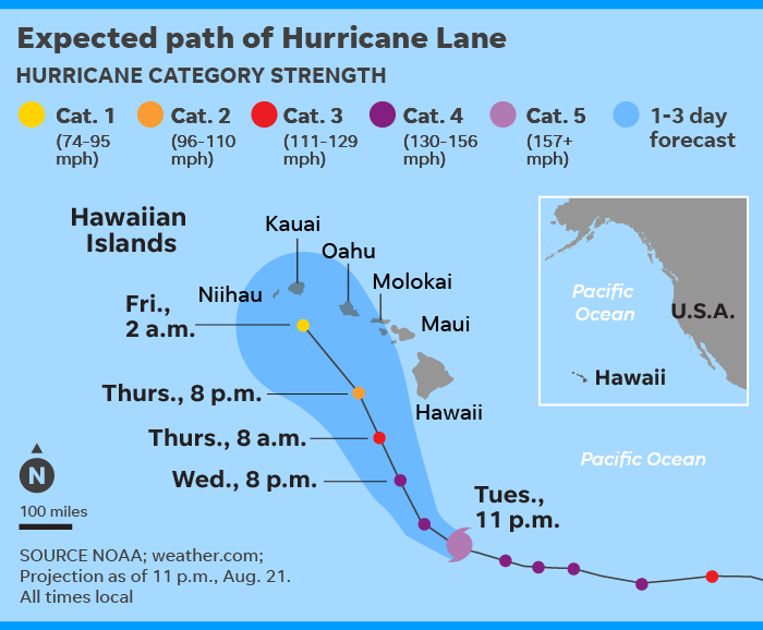
Hurricane Lane intensified to a Category 5 on Tuesday night, threatening to become the first landfalling hurricane in Hawaii in nearly three decades.
With maximum sustained winds of 160 mph, Lane was upgraded to the highest level on the Saffir-Simpson Hurricane Wind Scale as it surged westerly across the Pacific Ocean toward the Big Island. Unlike
Hurricane Hector, which skirted the Hawaiian Islands earlier this month, Lane is projected to veer north-northwest and drench the Aloha State’s most populated areas.
At 2 a.m. HST (8 a.m. EST), the hurricane was about 480 miles south southeast of Honolulu, traveling west northwest at 9 mph.
While Lane is likely to weaken as it moves closer to Hawaii, Accuweather Senior Meteorologist Mike Doll told USA TODAY that the hurricane will deliver a combination of torrential rainfall, high winds and dangerous surf as early as Wednesday.
“Regardless of what happens in the eye of the hurricane, there’s going to be the potential for a lot of rain – 10-15 inches, perhaps even higher than that,” Doll said. “The problem with that, you get that much rain and you’re going to be seeing damage to property. It’s certainly going to be a threat to lives, as well, especially in areas that are prone to flooding.” Big waves hit Hawaii on Thursday as
Hurricane Hector passed south of the Big Island. Hector weakened to a category 3 storm with maximum sustained winds of 125 mph.
(Aug. 10) AP
The hurricane’s escalation to Category 5 status motivated the Central Pacific Hurricane Center to issue a Hurricane Warning for Hawaii County, or the Big Island, indicating that damaging winds and surf and flooding rains are possible within 36 hours.
A hurricane watch was declared for the islands of Maui, Lanai, Molokai and Kahoolawe, and Oahu.
“Hurricane Lane is a very serious storm that has the potential to do damage and cause harm,” said Tom Travis, who heads the Hawaii Emergency Management Agency.
Also Tuesday, Hawaii Gov. David Ige signed an emergency proclamation to put the state in position to lend support to county emergency responders.
The state closed all government offices on Maui and the Big Island starting Wednesday. In addition, all University of Hawaii campuses were shut down on Maui and the Big Island, as well as Molokai and Lanai.
“We encourage all the people across the state to pay attention for this storm. It is different. It's not your typical hurricane that tracks south and goes away,” Ige said.
Indeed, Lane is forecast to turn north-northwest, or toward Honolulu, making it a threat to reach landfall – though in a weaker state.
“We expect it to be a Category 2 hurricane (then),” said Doll. But, he added, “That’s still a dangerous hurricane. Heed local warnings.”
A Category 3 hurricane at its peak, Hector followed a similar path toward Hawaii earlier this month but stayed south of the islands, causing “very little if any impact,” Doll said.
The last hurricane to make landfall in the island state was Iniki, a Category 4 that barreled into the island of Kauai on Sept. 11, 1992, and resulted in more than $3 billion in damages. Six people were killed.

There is a stuff ton of red tide everywhere along the coast of Florida and even in the cbrown towns, and now they are releasing even more water from Lake Okeechobee today, which means even more algae water is going into the ocean. yay, nothing like beaches being washed up with dead fish.